
Faça uma doação
Mapa topográfico Gibaja
Clique no mapa para exibir a altitude.
Faça uma doação
Sobre este mapa
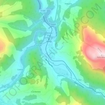
Nome: Mapa topográfico Gibaja, altitude, relevo.
Local: Gibaja, Ramales de la Victoria, Cantabria, 39809, Spain (43.25679 -3.45642 43.29679 -3.41642)
Altitude média: 212 m
Altitude mínima: 36 m
Altitude máxima: 663 m
Faça uma doação
Outros mapas topográficos
Clique em um mapa para visualizar sua topografia, sua altitude e seu relevo.
African Elephant, Water Buffalo and Southern Lechwe
Spain > Cantabria > Penagos > Cabárceno
Altitude média: 191 m
Faça uma doação
Potes
The town of Potes is located at the confluence of four valleys, near where the River Quiviesa flows in the River Deva, the latter born at altitudes of the Picos de Europa. Like the rest of the Liébana region, Potes enjoys a Mediterranean microclimate that allows the cultivation of the vines, walnut and…
Altitude média: 490 m
Cantabria
Towards the south are higher mountains, the tops of which form the watershed between the drainage basins of the Rivers Ebro, Duero and the rivers that flow into the Bay of Biscay. These peaks generally exceed 1,500 m (4,900 ft) from the Pass of San Glorio in the west to the Pass of Los Tornos in the eastern…
Altitude média: 609 m
Faça uma doação
Faça uma doação
Faça uma doação
Potes
The town of Potes is located at the confluence of four valleys, near where the River Quiviesa flows in the River Deva, the latter born at altitudes of the Picos de Europa. Like the rest of the Liébana region, Potes enjoys a Mediterranean microclimate that allows the cultivation of the vines, walnut and…
Altitude média: 490 m
Faça uma doação
Faça uma doação
Faça uma doação
Faça uma doação
Faça uma doação