
Mapa topográfico Indang
Mapa interativo
Clique no mapa para exibir a altitude.
Sobre este mapa
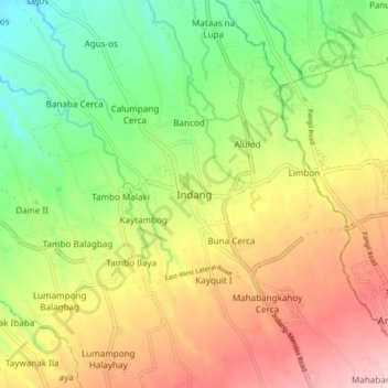
Nome: Mapa topográfico Indang, altitude, relevo.
Local: Indang, Cavite, Calabarzon, 4122, Philippines (14.15583 120.83841 14.23583 120.91841)
Altitude média: 298 m
Altitude mínima: 150 m
Altitude máxima: 477 m
The topography of Indang is characterised by gently sloping or rolling terrain. Almost 40.36% of its total land area is within the slope grade of 3-8%, while 2,135 hectares is within the slope range of 8-15% which is characterised by undulating or sloping terrain.