Mapa topográfico Barren River Lake
Mapa interativo
Clique no mapa para exibir a altitude.
Sobre este mapa
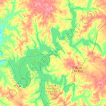
Nome: Mapa topográfico Barren River Lake, altitude, relevo.
Altitude média: 193 m
Altitude mínima: 144 m
Altitude máxima: 248 m

Clique no mapa para exibir a altitude.
Nome: Mapa topográfico Barren River Lake, altitude, relevo.
Altitude média: 193 m
Altitude mínima: 144 m
Altitude máxima: 248 m