
Mapa topográfico Unterrot
Mapa interativo
Clique no mapa para exibir a altitude.
Sobre este mapa
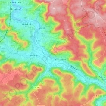
Nome: Mapa topográfico Unterrot, altitude, relevo.
Altitude média: 416 m
Altitude mínima: 321 m
Altitude máxima: 517 m
Outros mapas topográficos
Clique em um mapa para visualizar sua topografia, sua altitude e seu relevo.
Winzenweiler
Deutschland > Baden-Württemberg > Landkreis Schwäbisch Hall > Gaildorf
Winzenweiler, Eutendorf, Gaildorf, Verwaltungsverband Limpurger Land, Landkreis Schwäbisch Hall, Baden-Württemberg, 74405, Deutschland
Altitude média: 469 m