
Mapa topográfico Kings Canyon National Park
Mapa interativo
Clique no mapa para exibir a altitude.
Sobre este mapa
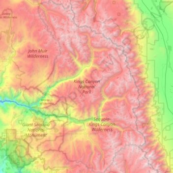
Nome: Mapa topográfico Kings Canyon National Park, altitude, relevo.
Altitude média: 2.591 m
Altitude mínima: 630 m
Altitude máxima: 4.372 m
Kings Canyon is characterized by some of the steepest vertical relief in North America, with numerous peaks over 14,000 feet (4,300 m) on the Sierra Crest along the park's eastern border, falling to 4,500 feet (1,400 m) in the valley floor of Cedar Grove just ten miles (16 km) to the west. The Sierran crest forms the eastern boundary of the park, from Mount Goethe in the north, down to Junction Peak, at the boundary with Sequoia National Park. Several passes cross the crest into the park, including Bishop Pass, Taboose Pass, Sawmill Pass, and Kearsarge Pass. All of these passes are above 11,000 feet (3,400 m) in elevation.
Outros mapas topográficos
Clique em um mapa para visualizar sua topografia, sua altitude e seu relevo.
Fresno
United States > California > Fresno County
Fresno, Fresno County, California, United States
Altitude média: 98 m
Pinehurst
United States > California > Fresno County
Pinehurst, Fresno County, California, 93641, United States
Altitude média: 1.244 m
Nellie Lake
United States > California > Fresno County
Nellie Lake, Fresno County, California, United States
Altitude média: 2.685 m
Kingsburg
United States > California > Fresno County
Kingsburg, Fresno County, California, United States
Altitude média: 93 m
Lake Italy
United States > California > Fresno County
Lake Italy, Fresno County, California, United States
Altitude média: 3.549 m
Helm
United States > California > Fresno County > Helm
Helm, Fresno County, California, 93627, United States
Altitude média: 56 m
Nelson Lakes
United States > California > Fresno County
Nelson Lakes, Fresno County, California, United States
Altitude média: 2.795 m
Clovis
United States > California > Fresno County > Clovis
Clovis, Fresno County, California, United States
Altitude média: 127 m
Fresno
United States > California > Fresno County
Fresno, Fresno County, CAL Fire Southern Region, California, United States
Altitude média: 99 m
Lakeshore
United States > California > Fresno County
Lakeshore, Fresno County, California, 93634, United States
Altitude média: 2.267 m