
Obrigado por apoiar este site ❤️
Faça uma doação
Faça uma doação
Mapa topográfico Valenzuela
Clique no mapa para exibir a altitude.
Obrigado por apoiar este site ❤️
Faça uma doação
Faça uma doação
Valenzuela
The highest elevation point is 38 metres (125 ft) above sea level. Having a surface gradient of 0.55% and a gentle slope, hilly landscape is located in the industrial section of the city in Canumay. The average elevation point is 2 metres (6.6 ft) above sea level.
Obrigado por apoiar este site ❤️
Faça uma doação
Faça uma doação
Sobre este mapa
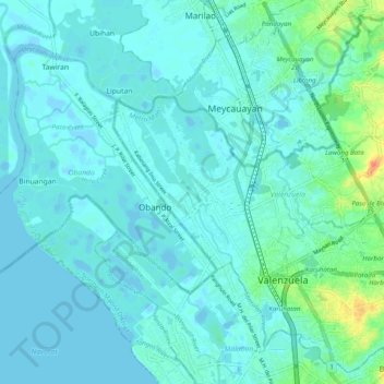
Nome: Mapa topográfico Valenzuela, altitude, relevo.
Local: Valenzuela, Metro Manila, Philippines (14.66875 120.92579 14.75839 121.02459)
Altitude média: 6 m
Altitude mínima: -4 m
Altitude máxima: 40 m
Obrigado por apoiar este site ❤️
Faça uma doação
Faça uma doação
Outros mapas topográficos
Clique em um mapa para visualizar sua topografia, sua altitude e seu relevo.