
Faça uma doação
Mapa topográfico Bedford
Clique no mapa para exibir a altitude.
Faça uma doação
Bedford
As with the rest of the United Kingdom, Bedford has a maritime climate, with a limited range of temperatures, and generally even rainfall throughout the year. The nearest Met Office weather station to Bedford is Bedford (Thurleigh) airport, about 6.5 miles (10.5 km) north of Bedford town centre at an elevation of 85 metres (279 ft). Temperature extremes at the site have ranged from 39.5 °C (103.1 °F) in July 2022, down to −15.3 °C (4.5 °F) in January 1982. However, such extremes would likely be superseded if longer-term records were available – Historically, the nearest weather station to Bedford was Cardington about 2.4 miles (3.9 km) south south east of the town centre with an elevation of 30 metres (98 ft). This location recorded a minimum of −18.3 °C (−0.9 °F) during January 1963.
Faça uma doação
Sobre este mapa
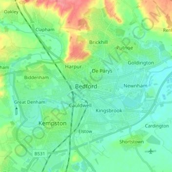
Nome: Mapa topográfico Bedford, altitude, relevo.
Local: Bedford, England, MK40 1SU, United Kingdom (52.09638 -0.50750 52.17638 -0.42750)
Altitude média: 37 m
Altitude mínima: 20 m
Altitude máxima: 84 m
Faça uma doação
Outros mapas topográficos
Clique em um mapa para visualizar sua topografia, sua altitude e seu relevo.