
Obrigado por apoiar este site ❤️
Faça uma doação
Faça uma doação
Mapa topográfico Silay
Clique no mapa para exibir a altitude.
Obrigado por apoiar este site ❤️
Faça uma doação
Faça uma doação
Sobre este mapa
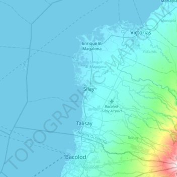
Nome: Mapa topográfico Silay, altitude, relevo.
Local: Silay, Negros Occidental, Western Visayas, 6116, Philippines (10.63941 122.81561 10.95941 123.13561)
Altitude média: 44 m
Altitude mínima: -1 m
Altitude máxima: 704 m
Obrigado por apoiar este site ❤️
Faça uma doação
Faça uma doação
Outros mapas topográficos
Clique em um mapa para visualizar sua topografia, sua altitude e seu relevo.
Cauayan
Philippines > Negros Occidental
The municipality of Cauayan has a rugged topography. Mt. Malipantao, considered the highest peak in the province, separates the municipality from the town of Candoni and the city of Sipalay. Portion of the ranges are the remaining thick forest that needs protection where the watershed is located. The remaining…
Altitude média: 91 m