

Mapa topográfico Wind
Clique no mapa para exibir a altitude.
Wind
Winds can shape landforms, via a variety of aeolian processes such as the formation of fertile soils, for example loess, and by erosion. Dust from large deserts can be moved great distances from its source region by the prevailing winds; winds that are accelerated by rough topography and associated with dust outbreaks have been assigned regional names in various parts of the world because of their significant effects on those regions. Wind also affects the spread of wildfires. Winds can disperse seeds from various plants, enabling the survival and dispersal of those plant species, as well as flying insect and bird populations. When combined with cold temperatures, the wind has a negative impact on livestock. Wind affects animals' food stores, as well as their hunting and defensive strategies.
Sobre este mapa
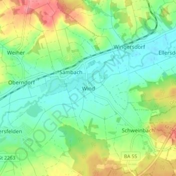
Nome: Mapa topográfico Wind, altitude, relevo.
Altitude média: 284 m
Altitude mínima: 257 m
Altitude máxima: 333 m
Outros mapas topográficos
Clique em um mapa para visualizar sua topografia, sua altitude e seu relevo.



Litzendorf
Germany > Bavaria > Landkreis Bamberg
Litzendorf and most of its outlying centres lie in the Ellern Valley, which is surrounded by wooded heights with the Bamberg district's two highest elevations, the Geisberg (585 m) and the Stammberg (560 m).
Altitude média: 362 m




Heiligenstadt i. OFr.
Germany > Bavaria > Landkreis Bamberg
Heiligenstadt lies in the Bamberg district’s southeastern corner. The 24 Gemeindeteile lie along the Leinleiter Valley and on the abutting Jura Plateau. Veilbronn lies 329 m above sea level. The greatest elevation is the Altenberg (mountain) behind Zoggendorf at 583 m above sea level. The villages on the…
Altitude média: 468 m