
Mapa topográfico Adjud
Mapa interativo
Clique no mapa para exibir a altitude.
Sobre este mapa
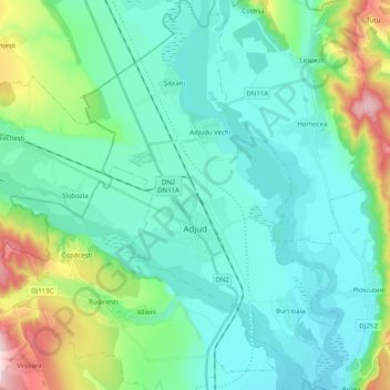
Nome: Mapa topográfico Adjud, altitude, relevo.
Local: Adjud, Vrancea, Romania (46.04291 27.12362 46.18147 27.25442)
Altitude média: 138 m
Altitude mínima: 77 m
Altitude máxima: 371 m
Adjud is situated on a plain and is surrounded by hills up to a height of 400 meters at the foot of the southern Carpathians. The average altitude of the town is 100 m above sea level. The surrounding land is favorable for agriculture.
Outros mapas topográficos
Clique em um mapa para visualizar sua topografia, sua altitude e seu relevo.