
Mapa topográfico Rome
Clique no mapa para exibir a altitude.
Rome
Although the city centre is about 24 km (15 mi) inland from the Tyrrhenian Sea, the city territory extends to the shore, where the south-western district of Ostia is located. The altitude of the central part of Rome ranges from 13 m (43 ft) above sea level (at the base of the Pantheon) to 139 m (456 ft) above sea level (the peak of Monte Mario). The Comune of Rome covers an overall area of about 1,285 km2 (496 sq mi), including many green areas.
Sobre este mapa
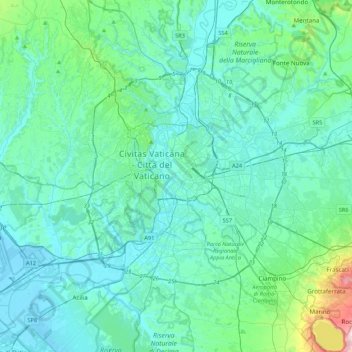
Nome: Mapa topográfico Rome, altitude, relevo.
Local: Rome, Roma Capitale, Lazio, 00100, Italy (41.73332 12.32293 42.05332 12.64293)
Altitude média: 78 m
Altitude mínima: -2 m
Altitude máxima: 648 m
Outros mapas topográficos
Clique em um mapa para visualizar sua topografia, sua altitude e seu relevo.
Albano Laziale
Italy > Lazio > Roma Capitale
The highest peak of the town of Albano is the Colle dei Cappuccini, located at 615 m above sea level. From the hill, which houses a pine forest adjacent to the Capuchin Monastery, there is a remarkable overview of Lake Albano, Agro Romano and Monte Cavo. The historic center of Albano has a maximum gradient of…
Altitude média: 302 m