
Obrigado por apoiar este site ❤️
Faça uma doação
Faça uma doação
Mapa topográfico Cheyenne
Clique no mapa para exibir a altitude.
Obrigado por apoiar este site ❤️
Faça uma doação
Faça uma doação
Cheyenne
The Cheyenne Regional Airport was opened in 1920, initially serving as a stop for airmail. It soon developed into a civil-military airport, serving DC-3s and various military craft. During World War II, hundreds of B-17s, B-24s, and PBYs were outfitted and upgraded at the airfield. Today, it serves a number of military functions, and as a high-altitude testbed for civilian craft.
Obrigado por apoiar este site ❤️
Faça uma doação
Faça uma doação
Sobre este mapa
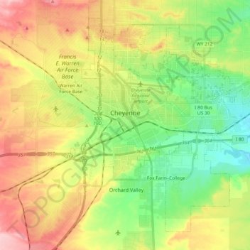
Nome: Mapa topográfico Cheyenne, altitude, relevo.
Local: Cheyenne, Laramie County, Wyoming, United States (41.07310 -104.86112 41.19303 -104.67493)
Altitude média: 1.871 m
Altitude mínima: 1.803 m
Altitude máxima: 1.962 m
Obrigado por apoiar este site ❤️
Faça uma doação
Faça uma doação
Outros mapas topográficos
Clique em um mapa para visualizar sua topografia, sua altitude e seu relevo.