
Faça uma doação
Mapa topográfico Sarangkot
Clique no mapa para exibir a altitude.
Faça uma doação
Sarangkot
The Ward is located on Sarangkot, a hill on the western side of Pokhara with an altitude of 1600m. Sarangkot is known for its panoramic Himalayan views of Dhaulagiri, Annapurna and Manaslu. It also provides an expansive view of the city of Pokhara, from the extreme north to the south including Phewa Lake. Tourists drive up the hill to watch the sunrise from the view tower at the top. In recent years, Sarangkot has been called one of the best paragliding locations in the world. The hike up from the Pokhara Baglung highway at Miruwa to Sarangkot takes 90 minutes to 1.5hours.
Faça uma doação
Sobre este mapa
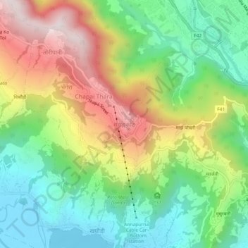
Nome: Mapa topográfico Sarangkot, altitude, relevo.
Local: Sarangkot, Pokhara, Kaski, Gandaki Province, 33700, Nepal (28.22452 83.92765 28.26452 83.96765)
Altitude média: 1.139 m
Altitude mínima: 795 m
Altitude máxima: 1.657 m
Faça uma doação
Outros mapas topográficos
Clique em um mapa para visualizar sua topografia, sua altitude e seu relevo.
Hadeban Upabhokta Samiti , Lamachaur -19
Nepal > Gandaki Province > Kaski > Pokhara
Altitude média: 1.042 m
Faça uma doação