
Obrigado por apoiar este site ❤️
Faça uma doação
Faça uma doação
Mapa topográfico Santurtzi
Clique no mapa para exibir a altitude.
Obrigado por apoiar este site ❤️
Faça uma doação
Faça uma doação
Santurtzi
Santurtzi has a very rough orography although excluding Mount Serantes (452m) - one of its most symbolic topographic elements, it is not at high altitude, the significant heights being spurs of the Serantes (Serandi): The Mallet (245m) and the Fortified heights (123 and 106m). Its relief is within the north flank of the anticline of Biscay. It is a relief of a structural type corresponding to a series of materials of the Cretaceous period (limestone) throughout Punta Lucero-Serantes smoothly inclined towards the Estuary of Bilbao.
Obrigado por apoiar este site ❤️
Faça uma doação
Faça uma doação
Sobre este mapa
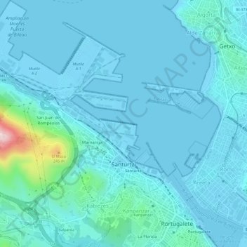
Nome: Mapa topográfico Santurtzi, altitude, relevo.
Altitude média: 34 m
Altitude mínima: -3 m
Altitude máxima: 360 m
Obrigado por apoiar este site ❤️
Faça uma doação
Faça uma doação