
Mapa topográfico Huanglong County
Mapa interativo
Clique no mapa para exibir a altitude.
Sobre este mapa
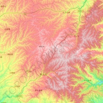
Nome: Mapa topográfico Huanglong County, altitude, relevo.
Local: Huanglong County, Yan'an, Shaanxi, China (35.40695 109.65546 36.03557 110.26765)
Altitude média: 1.275 m
Altitude mínima: 659 m
Altitude máxima: 1.765 m
Huanglong County is located approximately 221 kilometres (137 mi) from Yan'an's urban core, and 226 kilometres (140 mi) from Xi'an's urban core. Located in the Loess Plateau, Huanglong County is hilly in elevation, ranging from 643.7 metres (2,112 ft) to 1,738 metres (5,702 ft) in height. A number of minor rivers run through the county. 87% of Huanglong County is forested, and the county is home to 1,012 species of plants and 225 species of animals.