
Faça uma doação
Mapa topográfico Cleveland
Clique no mapa para exibir a altitude.
Faça uma doação
Sobre este mapa
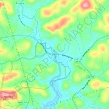
Nome: Mapa topográfico Cleveland, altitude, relevo.
Altitude média: 347 m
Altitude mínima: 297 m
Altitude máxima: 444 m
Faça uma doação
Outros mapas topográficos
Clique em um mapa para visualizar sua topografia, sua altitude e seu relevo.
Greenville
United States > South Carolina > Greenville County
Greenville features a varied topography characterized by rolling hills and the nearby Blue Ridge Mountains. The city sits at an elevation of approximately 984 feet (300 meters) above sea level, with its landscape shaped significantly by the Reedy River, which flows through the heart of downtown, creating…
Altitude média: 290 m
Simpsonville
United States > South Carolina > Greenville County
Simpsonville is located in southeastern Greenville County at 34°44′0″N 82°15′36″W / 34.73333°N 82.26000°W / 34.73333; -82.26000 (34.733375, -82.260001), between Mauldin to the northwest and Fountain Inn to the southeast. The center of town has an elevation of 866 feet (264 m) above sea level.
Altitude média: 259 m
Faça uma doação
Slater-Marietta
United States > South Carolina > Greenville County > Slater-Marietta
Altitude média: 325 m
Faça uma doação
Faça uma doação
Faça uma doação
Mountain Bridge Wilderness Area
United States > South Carolina > Greenville County
Altitude média: 680 m
Faça uma doação
Faça uma doação
Faça uma doação
Simpsonville
United States > South Carolina > Greenville County
Simpsonville is located in southeastern Greenville County at 34°44′0″N 82°15′36″W / 34.73333°N 82.26000°W / 34.73333; -82.26000 (34.733375, -82.260001), between Mauldin to the northwest and Fountain Inn to the southeast. The center of town has an elevation of 866 feet (264 m) above sea level.
Altitude média: 258 m