
Faça uma doação
Mapa topográfico Evol
Clique no mapa para exibir a altitude.
Faça uma doação
Sobre este mapa
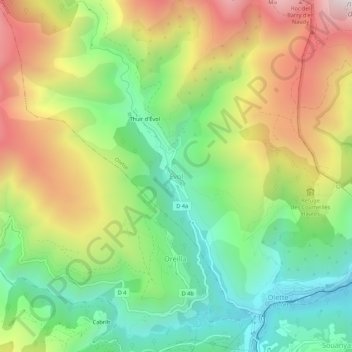
Nome: Mapa topográfico Evol, altitude, relevo.
Altitude média: 1.055 m
Altitude mínima: 599 m
Altitude máxima: 1.693 m
Faça uma doação
Outros mapas topográficos
Clique em um mapa para visualizar sua topografia, sua altitude e seu relevo.
Lac des Bouillouses
France > Occitania > Pyrénées-Orientales > Angoustrine-Villeneuve-des-Escaldes
Lac des Bouillouses or Llac de la Bollosa is a lake in Pyrénées-Orientales, France. At an elevation of 2017 m, its surface area is 1.49 km².
Altitude média: 2.091 m
Prats-de-Mollo-la-Preste
France > Occitania > Pyrénées-Orientales
Prats-de-Mollo-la-Preste is located in the Pyrenees, 13 km (8.1 mi) from the Spanish border and the Autonomous Community of Catalonia, on the banks of the river Tech, and on the south face of the Canigou at an elevation of 735 meters.
Altitude média: 1.295 m
Faça uma doação
Faça uma doação
Faça uma doação
Céret
France > Occitania > Pyrénées-Orientales
The town lies in the foothills of the Pyrénées mountains, in southern France, on the river Tech at an altitude of 175–1400 meters. It is 7 km (4.3 mi) from the Autoroute A9, 200 km (120 mi) from Montpellier, 250 km (160 mi) from Toulouse and 180 km (110 mi) from Barcelona. The GR 10 footpath runs close by.
Altitude média: 454 m
Saint-Paul-de-Fenouillet
France > Occitania > Pyrénées-Orientales > Saint-Paul-de-Fenouillet
Altitude média: 427 m
Faça uma doação
Faça uma doação