
Mapa topográfico Chinon
Mapa interativo
Clique no mapa para exibir a altitude.
Sobre este mapa
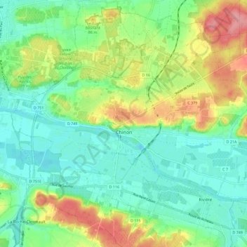
Nome: Mapa topográfico Chinon, altitude, relevo.
Altitude média: 58 m
Altitude mínima: 24 m
Altitude máxima: 124 m
Topography has played a major role: the formerly fortified town was developed at the foot of the castle on the rocky outcrop, protecting the northern side, with the Vienne River in the south. Apart from the natural defensive protection on both sides, this fact makes a long narrow urban space, with the main streets running parallel to the river.
Outros mapas topográficos
Clique em um mapa para visualizar sua topografia, sua altitude e seu relevo.
La Vrillonerie
France > Centre-Val de Loire > Indre-et-Loire > Chambray-lès-Tours
La Vrillonerie, Chambray-lès-Tours, Tours, Indre-et-Loire, Centre-Val de Loire, Metropolitan France, 37170, France
Altitude média: 89 m
Crotelles
France > Centre-Val de Loire > Indre-et-Loire
Crotelles, Loches, Indre-et-Loire, Centre-Val de Loire, Metropolitan France, 37380, France
Altitude média: 130 m
Tours
France > Centre-Val de Loire > Indre-et-Loire
Tours, Arrondissement de Tours, Indre-et-Loire, Centre-Val de Loire, Metropolitan France, France
Altitude média: 73 m
Rigny-Ussé
France > Centre-Val de Loire > Indre-et-Loire
Rigny-Ussé, Arrondissement de Tours, Indre-et-Loire, Centre-Val de Loire, Metropolitan France, 37420, France
Altitude média: 74 m