
Faça uma doação
Mapa topográfico Kirkland Lake
Clique no mapa para exibir a altitude.
Faça uma doação
Kirkland Lake
Kirkland Lake is located in the resource-rich Precambrian Shield, an ancient geological core of the North American continent. Nearby is the Arctic Watershed, a drainage divide at an elevation of 318 m (1,043 ft). Rivers south of that elevation flow into a drainage basin which includes Lake Ontario and the Saint Lawrence River, while rivers north of the watershed flow into Hudson Bay.
Faça uma doação
Sobre este mapa
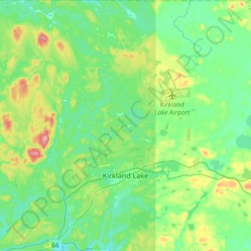
Nome: Mapa topográfico Kirkland Lake, altitude, relevo.
Altitude média: 332 m
Altitude mínima: 294 m
Altitude máxima: 443 m
Faça uma doação
Outros mapas topográficos
Clique em um mapa para visualizar sua topografia, sua altitude e seu relevo.
Henwood Lake
Canada > Ontario > Timiskaming District > Unorganized West Timiskaming
Altitude média: 288 m
Faça uma doação
Faça uma doação
Boston Creek
Canada > Ontario > Timiskaming District > Unorganized West Timiskaming
Altitude média: 300 m
Heart Lake
Canada > Ontario > Timiskaming District > Unorganized West Timiskaming > King Kirkland
Altitude média: 336 m
Faça uma doação
Hobart Lake
Canada > Ontario > Timiskaming District > Unorganized West Timiskaming
Altitude média: 305 m
Flanagan Lake
Canada > Ontario > Timiskaming District > Unorganized West Timiskaming
Altitude média: 403 m
Faça uma doação
Baptiste Creek;Baptiste Lake
Canada > Ontario > Timiskaming District > Unorganized West Timiskaming
Altitude média: 334 m
Faça uma doação