
Mapa topográfico Attendorn
Mapa interativo
Clique no mapa para exibir a altitude.
Attendorn
The town of Attendorn lies in the Naturpark Ebbegebirge, right on the Biggesee (lake) in the district's northwest. The town's highest point is the Rüenhardt (636 m), whereas the Ahauser Stausee (reservoir) has an elevation of only 248 m. The municipal area comprises 97 km², roughly half of which is wooded. It is a part of South Westphalia.
Sobre este mapa
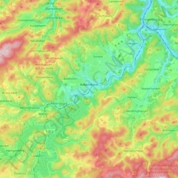
Nome: Mapa topográfico Attendorn, altitude, relevo.
Local: Attendorn, Kreis Olpe, North Rhine-Westphalia, 57439, Germany (51.07271 7.79579 51.17069 8.00401)
Altitude média: 384 m
Altitude mínima: 229 m
Altitude máxima: 630 m
Outros mapas topográficos
Clique em um mapa para visualizar sua topografia, sua altitude e seu relevo.
Altfinnentrop
Germany > North Rhine-Westphalia > Kreis Olpe > Finnentrop > Heggen
Altitude média: 316 m
Rüblinghausen
Germany > North Rhine-Westphalia > Kreis Olpe > Olpe > Rüblinghausen
Altitude média: 371 m