
Mapa topográfico Mount Washington Wilderness
Mapa interativo
Clique no mapa para exibir a altitude.
Sobre este mapa
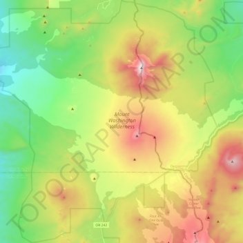
Nome: Mapa topográfico Mount Washington Wilderness, altitude, relevo.
Altitude média: 1.500 m
Altitude mínima: 993 m
Altitude máxima: 2.275 m
There are forest roads which extend to the base of Mount Washington. The Pacific Crest Trail is the major path through the Mount Washington Wilderness, extending 16.6 miles (26.7 km) from the northern to southern edge of the area. Traversing lodgepole pine forest and lava flows, the trail passes over the western side of Mount Washington. The hike is challenging, ranging in elevation from 4,700 to 6,100 feet (1,400 to 1,900 m) with little sources of water. Other trails include a loop around the Patjens Lakes, the Hand Lake trail, and the Benson Lake route. Friendly for families and children, the Patjens Lake trail runs for 6 miles (9.7 km), only gaining 350 feet (110 m) in elevation. Water is abundant along the route, which passes through lodgepole pine forests with the occasional meadow. The Hand Lake and Benson Lake trails are also easy day hikes, lasting 0.5 miles (0.80 km) and 1.4 miles (2.3 km), respectively. One of the trails within the wilderness area, known as the Dry Creek Trail, is not maintained by the United States Forest Service and is no longer recommended as a hiking route due to fallen trees in fire-damaged forest. The U.S. National Geodetic Survey Data Sheet for Mount Washington notes that climbing the volcano is challenging and dangerous and thus is not recommended for inexperienced climbers or climbers without proper equipment.
Outros mapas topográficos
Clique em um mapa para visualizar sua topografia, sua altitude e seu relevo.
Albany
United States > Oregon > Linn County
Albany, Linn County, Oregon, United States
Altitude média: 71 m
Tangent
United States > Oregon > Linn County
Tangent, Linn County, Oregon, United States
Altitude média: 75 m
Millersburg
United States > Oregon > Linn County
Millersburg, Linn County, Oregon, United States
Altitude média: 73 m
Lebanon
United States > Oregon > Linn County
Lebanon, Linn County, Oregon, 97355, United States
Altitude média: 117 m
Menagerie Wilderness
United States > Oregon > Linn County
Menagerie Wilderness, Forest Road 306, Linn County, Oregon, United States
Altitude média: 819 m
Cascadia
United States > Oregon > Linn County
Cascadia, Linn County, Oregon, 97329, United States
Altitude média: 415 m
Scio
United States > Oregon > Linn County
Scio, Linn County, Oregon, 97374, United States
Altitude média: 106 m
Mill City
United States > Oregon > Linn County
Mill City, Linn County, Oregon, 97360, United States
Altitude média: 292 m
Halsey
United States > Oregon > Linn County
Halsey, Linn County, Oregon, United States
Altitude média: 86 m
Lyons
United States > Oregon > Linn County
Lyons, Linn County, Oregon, United States
Altitude média: 223 m
Ward Butte
United States > Oregon > Linn County
Ward Butte, Linn County, Oregon, United States
Altitude média: 89 m
Brownsville
United States > Oregon > Linn County
Brownsville, Linn County, Oregon, 97327, United States
Altitude média: 116 m
Ed Rogers Wayside
United States > Oregon > Linn County
Ed Rogers Wayside, Linn County, Oregon, United States
Altitude média: 492 m
Sodaville
United States > Oregon > Linn County > Sodaville
Sodaville, Linn County, Oregon, United States
Altitude média: 168 m
Sweet Home
United States > Oregon > Linn County
Sweet Home, Linn County, Oregon, 97386, United States
Altitude média: 230 m
Jordan
United States > Oregon > Linn County > Jordan
Jordan, Linn County, Oregon, United States
Altitude média: 200 m
Lacomb
United States > Oregon > Linn County
Lacomb, Linn County, Oregon, United States
Altitude média: 189 m
Middle Santiam Wilderness
United States > Oregon > Linn County
Middle Santiam Wilderness, Linn County, Oregon, United States
Altitude média: 953 m