
Mapa topográfico Rotorua
Mapa interativo
Clique no mapa para exibir a altitude.
Sobre este mapa
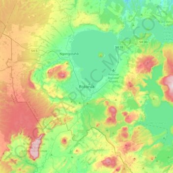
Nome: Mapa topográfico Rotorua, altitude, relevo.
Altitude média: 435 m
Altitude mínima: 215 m
Altitude máxima: 860 m
Outros mapas topográficos
Clique em um mapa para visualizar sua topografia, sua altitude e seu relevo.
Ngongotahā
New Zealand > Bay of Plenty > Rotorua Lakes District
Ngongotahā, Rotorua Lakes District, Bay of Plenty, New Zealand
Altitude média: 339 m
Lake Rotorua
New Zealand > Bay of Plenty > Rotorua Lakes District > Hamurana
Lake Rotorua, Hamurana, Rotorua Lakes District, Bay of Plenty, 3040, New Zealand
Altitude média: 299 m
Lake Okareka
New Zealand > Bay of Plenty > Rotorua Lakes District
Lake Okareka, Rotorua Lakes District, Bay of Plenty, New Zealand
Altitude média: 441 m