
Mapa topográfico Bispingen
Mapa interativo
Clique no mapa para exibir a altitude.
Sobre este mapa
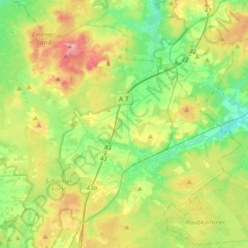
Nome: Mapa topográfico Bispingen, altitude, relevo.
Local: Bispingen, Heidekreis, Lower Saxony, 29646, Germany (53.05600 9.86038 53.18087 10.11836)
Altitude média: 91 m
Altitude mínima: 47 m
Altitude máxima: 167 m
Outros mapas topográficos
Clique em um mapa para visualizar sua topografia, sua altitude e seu relevo.
Bad Fallingbostel
Germany > Lower Saxony > Heidekreis
Bad Fallingbostel, Heidekreis, Lower Saxony, 29683, Germany
Altitude média: 64 m
Walsrode
Germany > Lower Saxony > Heidekreis
Walsrode, Heidekreis, Lower Saxony, Germany
Altitude média: 48 m
Schülern
Germany > Lower Saxony > Heidekreis > Schneverdingen > Schülern
Schülern, Schneverdingen, Heidekreis, Lower Saxony, 29640, Germany
Altitude média: 80 m
Soltau
Germany > Lower Saxony > Heidekreis > Soltau
Soltau, Heidekreis, Lower Saxony, 29614, Germany
Altitude média: 78 m