
Faça uma doação
Mapa topográfico Swinton
Clique no mapa para exibir a altitude.
Faça uma doação
Swinton
Swinton lies at 53°30′44″N 2°20′28″W / 53.51222°N 2.34111°W / 53.51222; -2.34111 (53.5122°, -2.3412°), 167 miles (269 km) northwest of central London, and 4.2 miles (6.8 km) west-northwest of Manchester city centre. Topographically, Swinton occupies an area of gently sloping ground, roughly 213 feet (65 m) above sea level, and is on the south side of the River Irwell. Swinton lies in the west-central part of the Greater Manchester Urban Area, the UK's second largest conurbation. The M60 motorway passes Swinton on its northwest side.
Faça uma doação
Sobre este mapa
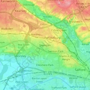
Nome: Mapa topográfico Swinton, altitude, relevo.
Altitude média: 59 m
Altitude mínima: 16 m
Altitude máxima: 138 m
Faça uma doação
Outros mapas topográficos
Clique em um mapa para visualizar sua topografia, sua altitude e seu relevo.