
Mapa topográfico Tongass National Forest
Mapa interativo
Clique no mapa para exibir a altitude.
Sobre este mapa
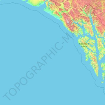
Nome: Mapa topográfico Tongass National Forest, altitude, relevo.
Altitude média: 156 m
Altitude mínima: -4 m
Altitude máxima: 4.094 m
Historically, logging operations tended to concentrate on lower-elevation, bigger-tree ecosystems for harvesting; at present, approximately 78% of the land remains intact, i.e. 383,000 acres (1,550 km2) out of 491,000 acres (1,990 km2) original big-tree, low-elevation forest area. Given the high value of these areas for wildlife species, close to 70% of this old growth forest is protected in reserves and will never be eligible for harvest.
Outros mapas topográficos
Clique em um mapa para visualizar sua topografia, sua altitude e seu relevo.
Clarence Kramer Peak
United States > Alaska > Sitka > Sitka
Clarence Kramer Peak, Sitka, Alaska, United States
Altitude média: 751 m
North Sister
United States > Alaska > Sitka > Sitka
North Sister, Sitka, Alaska, United States
Altitude média: 507 m
Beaver Lake
United States > Alaska > Sitka > Sitka
Beaver Lake, Sitka, Alaska, United States
Altitude média: 313 m
Fleming Island
United States > Alaska > Sitka
Fleming Island, Sitka, Alaska, United States
Altitude média: 149 m
Mount Edgecumbe
United States > Alaska > Sitka
Mount Edgecumbe, Sitka, Alaska, United States
Altitude média: 597 m