
Obrigado por apoiar este site ❤️
Faça uma doação
Faça uma doação
Mapa topográfico Clayton West
Clique no mapa para exibir a altitude.
Obrigado por apoiar este site ❤️
Faça uma doação
Faça uma doação
Clayton West
Listed as Clayton, West, the village featured in "A Topographical Dictionary of England" which was published by Samuel Lewis, London, 1848. In 1848 the village had 1440 residents and was described as being 1080 acres belonging to various owners. Mining was listed as the predominant industry, along with the production of silk and worsted goods for clothing. The account states that many large mills had been constructed in the village for this purpose. In 1848 the four places of worship were listed.
Obrigado por apoiar este site ❤️
Faça uma doação
Faça uma doação
Sobre este mapa
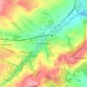
Nome: Mapa topográfico Clayton West, altitude, relevo.
Altitude média: 150 m
Altitude mínima: 79 m
Altitude máxima: 236 m
Obrigado por apoiar este site ❤️
Faça uma doação
Faça uma doação
Outros mapas topográficos
Clique em um mapa para visualizar sua topografia, sua altitude e seu relevo.