
Mapa topográfico Canyon City
Mapa interativo
Clique no mapa para exibir a altitude.
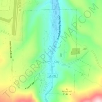
Canyon City
The city is at an elevation of about 3,200 feet (980 m). Between Canyon City and Burns, to the south, Route 395 passes through parts of the Malheur National Forest. According to the United States Census Bureau, the town has a total area of 1.41 square miles (3.65 km2), all land.
Sobre este mapa
Nome: Mapa topográfico Canyon City, altitude, relevo.
Local: Canyon City, Grant County, Oregon, 97820, United States (44.38124 -118.96065 44.40346 -118.93560)
Altitude média: 1.078 m
Altitude mínima: 955 m
Altitude máxima: 1.293 m