
Mapa topográfico Wymondham
Clique no mapa para exibir a altitude.
Wymondham
Wymondham's topography is marked by its river meadow and flat, low-lying agricultural landscape, much like the rest of East Anglia. The parish has an area of 17.11 square miles (44.31 km2). The geology is based on chalk, with a layer of boulder clay laid down in the last ice age. The River Tiffey, flowing north, forms a boundary between the built-up town centre and the rural southern part of the parish.
Sobre este mapa
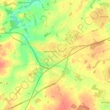
Nome: Mapa topográfico Wymondham, altitude, relevo.
Local: Wymondham, South Norfolk, Norfolk, England, NR18, United Kingdom (52.53735 1.07661 52.61070 1.16459)
Altitude média: 43 m
Altitude mínima: 14 m
Altitude máxima: 65 m
Outros mapas topográficos
Clique em um mapa para visualizar sua topografia, sua altitude e seu relevo.
Poringland Wood
United Kingdom > England > Norfolk > South Norfolk > Framingham Earl
Altitude média: 50 m
Fundenhall
United Kingdom > England > Norfolk > South Norfolk > Ashwellthorpe and Fundenhall
Altitude média: 50 m
Beckhithe
United Kingdom > England > Norfolk > South Norfolk > Little Melton > Beckhithe
Altitude média: 37 m
Forncett Saint Mary
United Kingdom > England > Norfolk > South Norfolk > Forncett St Peter
Altitude média: 43 m