
Mapa topográfico Grasonville
Mapa interativo
Clique no mapa para exibir a altitude.
Sobre este mapa
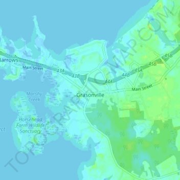
Nome: Mapa topográfico Grasonville, altitude, relevo.
Altitude média: 3 m
Altitude mínima: -2 m
Altitude máxima: 12 m
Outros mapas topográficos
Clique em um mapa para visualizar sua topografia, sua altitude e seu relevo.
Kent Island
United States > Maryland > Queen Anne's County > Chester
Kent Island, Chester, Queen Anne's County, Maryland, United States
Altitude média: 1 m
Tuckahoe State Park
United States > Maryland > Queen Anne's County > Waljacks Corners
Tuckahoe State Park, Queen Anne Highway, Waljacks Corners, Queen Anne's County, Maryland, 21657, United States
Altitude média: 17 m
Chester
United States > Maryland > Queen Anne's County > Chester
Chester, Queen Anne's County, Maryland, United States
Altitude média: 2 m
Centreville
United States > Maryland > Queen Anne's County
Centreville, Queen Anne's County, Maryland, United States
Altitude média: 15 m
Stevensville
United States > Maryland > Queen Anne's County
Stevensville, Queen Anne's County, Maryland, United States
Altitude média: 2 m