
Mapa topográfico Blackdown
Mapa interativo
Clique no mapa para exibir a altitude.
Sobre este mapa
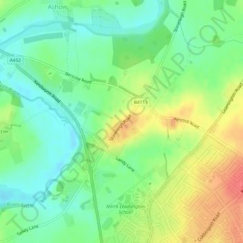
Nome: Mapa topográfico Blackdown, altitude, relevo.
Altitude média: 69 m
Altitude mínima: 47 m
Altitude máxima: 99 m
Outros mapas topográficos
Clique em um mapa para visualizar sua topografia, sua altitude e seu relevo.
Norton Lindsey
United Kingdom > England > Warwick > Norton Lindsey
Norton Lindsey, Warwick, Warwickshire, West Midlands, England, United Kingdom
Altitude média: 93 m
Beausale
United Kingdom > England > Warwick > Beausale
Beausale, Beausale, Haseley, Honiley and Wroxall, Warwick, Warwickshire, West Midlands, England, CV35 7NR, United Kingdom
Altitude média: 112 m
Kenilworth Castle
United Kingdom > England > Warwick
Kenilworth Castle, Purlieu Lane, Kenilworth, Warwick, Warwickshire, West Midlands, England, CV8 1PQ, United Kingdom
Altitude média: 87 m
Bishops Tachbrook
United Kingdom > England > Warwick > Bishops Tachbrook
Bishops Tachbrook, Warwick, Warwickshire, West Midlands, England, CV33 9RJ, United Kingdom
Altitude média: 71 m
Stoneleigh
United Kingdom > England > Warwick > Stoneleigh
Stoneleigh, Warwick, Warwickshire, West Midlands, England, CV8 3DH, United Kingdom
Altitude média: 72 m
Beausale, Haseley, Honiley and Wroxall
United Kingdom > England > Warwick
Beausale, Haseley, Honiley and Wroxall, Warwick, Warwickshire, West Midlands, England, United Kingdom
Altitude média: 111 m