
Obrigado por apoiar este site ❤️
Faça uma doação
Faça uma doação
Mapa topográfico Don Carlos
Clique no mapa para exibir a altitude.
Obrigado por apoiar este site ❤️
Faça uma doação
Faça uma doação
Don Carlos
The terrain of the municipality of Don Carlos is generally flat except the mountain range on the eastern part of the municipality. The highest elevation is 700 metres (2,300 ft) above sea level and the lowest elevation is 300 metres (980 ft) below sea level.
Obrigado por apoiar este site ❤️
Faça uma doação
Faça uma doação
Sobre este mapa
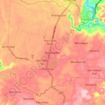
Nome: Mapa topográfico Don Carlos, altitude, relevo.
Local: Don Carlos, Bukidnon, Northern Mindanao, 088, Philippines (7.64036 124.95907 7.72036 125.03907)
Altitude média: 299 m
Altitude mínima: 161 m
Altitude máxima: 355 m
Obrigado por apoiar este site ❤️
Faça uma doação
Faça uma doação
Outros mapas topográficos
Clique em um mapa para visualizar sua topografia, sua altitude e seu relevo.