
Faça uma doação
Mapa topográfico Sibuyan Island
Clique no mapa para exibir a altitude.
Faça uma doação
Sibuyan Island
Sibuyan is a crescent-shaped island, the second largest in an archipelago comprising Romblon Province, Philippines. Located in the namesake Sibuyan Sea, it has an area of 445 square kilometres (172 sq mi) and has a total population of 62,815, as of the 2020 census. The island has two prominent peaks, the highest is Mount Guiting-Guiting, with an elevation of 2,058 metres (6,752 ft), followed by Mount Nailog, which is 789 metres (2,589 ft) high. The people speak the Sibuyanon dialect of Romblomanon, a Visayan language.
Faça uma doação
Sobre este mapa
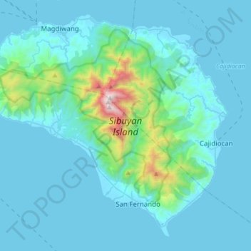
Nome: Mapa topográfico Sibuyan Island, altitude, relevo.
Local: Sibuyan Island, Romblon, Mimaropa, Philippines (12.26705 122.42342 12.50612 122.69900)
Altitude média: 182 m
Altitude mínima: -1 m
Altitude máxima: 1.991 m
Faça uma doação
Outros mapas topográficos
Clique em um mapa para visualizar sua topografia, sua altitude e seu relevo.