
Faça uma doação
Mapa topográfico Highland Park
Clique no mapa para exibir a altitude.
Faça uma doação
Highland Park
In 1867, ten men purchased Highland Park for $39,198.70. They were the original stockholders of the Highland Park Building Company. Following construction of the Chicago and Milwaukee Railroad, a depot was established at Highland Park and a plat, extending south to Central Avenue, was laid out in 1856. At that point, Highland Park was settled on mostly scattered farms and undeveloped forested land. Highland Park was established as a city on March 11, 1869, with a population of 500, and evolved from the two settlements of St. John and Port Clinton; St. John's Avenue and Port Clinton Square are named after the settlements. Highland Park was named from its parklike setting at a lofty elevation relative to the lake, and was given its name from Walter S. Gurnee. The town annexed the village of Ravinia in 1899.
Faça uma doação
Sobre este mapa
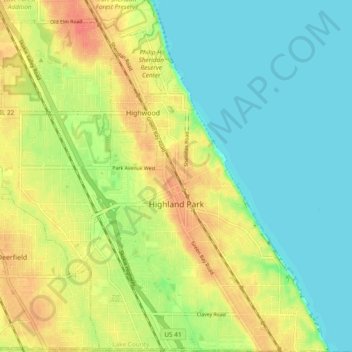
Nome: Mapa topográfico Highland Park, altitude, relevo.
Local: Highland Park, Lake County, Illinois, United States (42.15226 -87.85206 42.22231 -87.75885)
Altitude média: 193 m
Altitude mínima: 174 m
Altitude máxima: 220 m
Faça uma doação
Outros mapas topográficos
Clique em um mapa para visualizar sua topografia, sua altitude e seu relevo.
Faça uma doação
Faça uma doação
Faça uma doação
Lake Naomi
United States > Illinois > Lake County > Hawthorn Woods > White Birch Lakes
Altitude média: 261 m