
Mapa topográfico Alcorriol
Clique no mapa para exibir a altitude.
Sobre este mapa
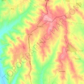
Nome: Mapa topográfico Alcorriol, altitude, relevo.
Local: Alcorriol, Torres Novas, Santarém, 2350-077, Portugal (39.50497 -8.54352 39.54497 -8.50352)
Altitude média: 113 m
Altitude mínima: 41 m
Altitude máxima: 162 m
Outros mapas topográficos
Clique em um mapa para visualizar sua topografia, sua altitude e seu relevo.
Monumento Natural das Pegadas de Dinossáurios de Ourém/Torres Novas
Portugal > Santarém > Torres Novas > Chancelaria
Altitude média: 289 m