
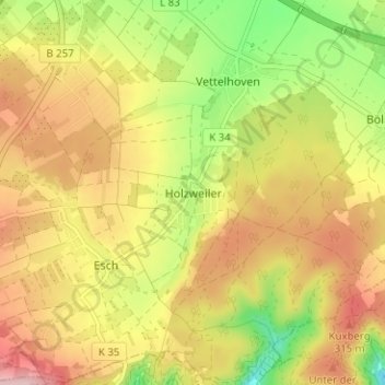
Mapa topográfico Holzweiler
Mapa interativo
Clique no mapa para exibir a altitude.
Sobre este mapa
Nome: Mapa topográfico Holzweiler, altitude, relevo.
Altitude média: 256 m
Altitude mínima: 150 m
Altitude máxima: 350 m
Outros mapas topográficos
Clique em um mapa para visualizar sua topografia, sua altitude e seu relevo.
Vettelhoven
Deutschland > Rheinland-Pfalz > Landkreis Ahrweiler > Grafschaft
Vettelhoven, Grafschaft, Landkreis Ahrweiler, Rheinland-Pfalz, 53507, Deutschland
Altitude média: 242 m
Gelsdorf
Deutschland > Rheinland-Pfalz > Landkreis Ahrweiler > Grafschaft
Gelsdorf, Grafschaft, Landkreis Ahrweiler, Rheinland-Pfalz, 53340, Deutschland
Altitude média: 223 m
Bölingen
Deutschland > Rheinland-Pfalz > Landkreis Ahrweiler > Grafschaft > Bölingen
Bölingen, Grafschaft, Landkreis Ahrweiler, Rheinland-Pfalz, 53501, Deutschland
Altitude média: 226 m