
Mapa topográfico Bentworth
Mapa interativo
Clique no mapa para exibir a altitude.
Sobre este mapa
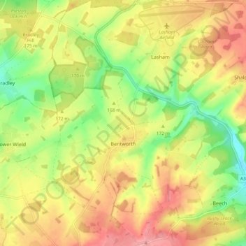
Nome: Mapa topográfico Bentworth, altitude, relevo.
Local: Bentworth, East Hampshire, Hampshire, Angleterre, Royaume-Uni (51.13288 -1.07749 51.19052 -1.01388)
Altitude média: 169 m
Altitude mínima: 110 m
Altitude máxima: 223 m
Outros mapas topográficos
Clique em um mapa para visualizar sua topografia, sua altitude e seu relevo.
Goatacre
Royaume-Uni > Angleterre > Hampshire > East Hampshire > Medstead
Goatacre, Medstead, East Hampshire, Hampshire, Angleterre, GU34 5NA, Royaume-Uni
Altitude média: 179 m
Steep
Royaume-Uni > Angleterre > Hampshire > East Hampshire
Steep, East Hampshire, Hampshire, Angleterre, Royaume-Uni
Altitude média: 115 m