
Obrigado por apoiar este site ❤️
Faça uma doação
Faça uma doação
Mapa topográfico Dume
Clique no mapa para exibir a altitude.
Obrigado por apoiar este site ❤️
Faça uma doação
Faça uma doação
Sobre este mapa
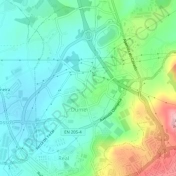
Nome: Mapa topográfico Dume, altitude, relevo.
Local: Dume, Real, Dume e Semelhe, Braga, Portugal (41.55760 -8.44488 41.58415 -8.42031)
Altitude média: 100 m
Altitude mínima: 50 m
Altitude máxima: 229 m
Obrigado por apoiar este site ❤️
Faça uma doação
Faça uma doação
Outros mapas topográficos
Clique em um mapa para visualizar sua topografia, sua altitude e seu relevo.
Braga
The topography in the municipality is characterized by irregular valleys, interspersed by mountainous spaces, fed by rivers running in parallel with the principal rivers. In the north it is limited by the Cávado River, in the south by terrain of the Serra dos Picos to a height of 566 metres (1,857 ft) and…
Altitude média: 204 m
Obrigado por apoiar este site ❤️
Faça uma doação
Faça uma doação