Mapa topográfico Varanasi
Clique no mapa para exibir a altitude.
Varanasi
Varanasi is located at an elevation of 80.71 metres (264.8 ft) in the centre of the Ganges valley of North India, in the Eastern part of the state of Uttar Pradesh, along the left crescent-shaped bank of the Ganges, averaging between 15 metres (50 ft) and 21 metres (70 ft) above the river. The city is the headquarters of Varanasi district. By road, Varanasi is located 797 kilometres (495 mi) south-east of New Delhi, 320 kilometres (200 mi) south-east of Lucknow, 121 kilometres (75 mi) east of Allahabad, and 63 kilometres (39 mi) south of Jaunpur. The "Varanasi Urban Agglomeration" – an agglomeration of seven urban sub-units – covers an area of 112 km2 (43 sq mi). Neighbourhoods of the city include Adampura, Anandbagh, Bachchhaon, Bangali Tola, Bhelpura, Bulanala, Chaitganj, Chaukaghat, Chowk, Dhupchandi, Dumraon, Gandhinagar, Gautam Nagar, Giri Nagar, Gopal Vihar, Guru Nanak Nagar, Jaitpura, Kail Garh, Khanna, Kotwali, Lanka Manduadih, Luxa, Maheshpur, Mahmoorganj, Maulvibagh, Nagwar, Naipokhari, Shivala, Siddhagiribagh, and Sigra.
Sobre este mapa
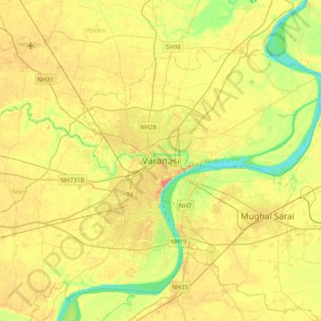
Nome: Mapa topográfico Varanasi, altitude, relevo.
Local: Varanasi, Sadar, Varanasi, Uttar Pradesh, 221001, India (25.17565 82.84763 25.49565 83.16763)
Altitude média: 77 m
Altitude mínima: 55 m
Altitude máxima: 96 m
Outros mapas topográficos
Clique em um mapa para visualizar sua topografia, sua altitude e seu relevo.