
Faça uma doação
Mapa topográfico Hidden Valley Lake
Clique no mapa para exibir a altitude.
Faça uma doação
Sobre este mapa
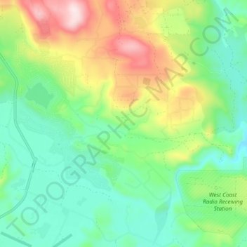
Nome: Mapa topográfico Hidden Valley Lake, altitude, relevo.
Altitude média: 389 m
Altitude mínima: 240 m
Altitude máxima: 690 m
Faça uma doação
Outros mapas topográficos
Clique em um mapa para visualizar sua topografia, sua altitude e seu relevo.
Clear Lake
United States > California > Lake County > Lakeport
Clear Lake is 19 mi (31 km) by 8 mi (13 km) at its widest point, with a surface area of 43,785 acres (17,719 ha) and a 1,155,000 acre⋅ft (1,425,000 dam3) capacity. Average depth is 27 ft (8.2 m), maximum is 60 ft (18 m), lake elevation is 1,329 ft (405 m), and average water temperature is 40 °F (4 °C) in…
Altitude média: 531 m
Upper Lake
United States > California > Lake County
Upper Lake is a census-designated place (CDP) in Lake County, California, United States. Upper Lake is located 8 miles (13 km) north of Lakeport, at an elevation of 1,345 feet (410 m). The population was 1,052 at the 2010 census, up from 989 at the 2000 census. The Habematolel Pomo of Upper Lake are…
Altitude média: 429 m
Faça uma doação
Cobb
United States > California > Lake County
Cobb is a census designated place (CDP) in Lake County, California, United States. Cobb is located 1 mile (1.6 km) northwest of Whispering Pines, at an elevation of 2,631 feet (802 m). The population was 1,778 at the 2010 census, up from 1,638 at the 2000 census.
Altitude média: 887 m