
Mapa topográfico Newton
Mapa interativo
Clique no mapa para exibir a altitude.
Newton
Newton has grown around a formation of seven hills. "The general features of Newton are not without interest. Seven principal elevations mark its surface, like the seven hills of ancient Rome, with the difference that the seven hills of Newton are much more distinct than the seven hills of Rome: Nonantum Hill, Waban Hill, Chestnut Hill, Bald Pate, Oak Hill, Institution Hill and Mount Ida."
Sobre este mapa
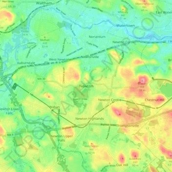
Nome: Mapa topográfico Newton, altitude, relevo.
Altitude média: 43 m
Altitude mínima: -3 m
Altitude máxima: 186 m
Outros mapas topográficos
Clique em um mapa para visualizar sua topografia, sua altitude e seu relevo.