
Obrigado por apoiar este site ❤️
Faça uma doação
Faça uma doação
Mapa topográfico Balzac
Clique no mapa para exibir a altitude.
Obrigado por apoiar este site ❤️
Faça uma doação
Faça uma doação
Sobre este mapa
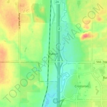
Nome: Mapa topográfico Balzac, altitude, relevo.
Local: Balzac, Rocky View County, Alberta, T0M 0E0, Canada (51.19561 -114.02456 51.23561 -113.98456)
Altitude média: 1.088 m
Altitude mínima: 1.066 m
Altitude máxima: 1.117 m
Obrigado por apoiar este site ❤️
Faça uma doação
Faça uma doação
Outros mapas topográficos
Clique em um mapa para visualizar sua topografia, sua altitude e seu relevo.
Obrigado por apoiar este site ❤️
Faça uma doação
Faça uma doação
Langdon
Canada > Alberta > Rocky View County
Langdon is located 12 km (7.5 mi) east of the City of Calgary at the intersection of Highway 560 (Glenmore Trail) and Highway 797, approximately 6 km (3.7 mi) south of the Trans Canada Highway and 7 km (4.3 mi) north of Highway 22X. It has an elevation of 1,005 m (3,297 ft).
Altitude média: 1.007 m