
Faça uma doação
Mapa topográfico Snellville
Clique no mapa para exibir a altitude.
Faça uma doação
Snellville
Compared to most large cities around the world at approximately the same latitude (33°39'), such as Beirut, Casablanca, Dallas, Los Angeles, and Phoenix, Snellville has lower average winter temperatures. The primary reason for this is that the North American continent extends into high latitudes that allows systems to form and move eastward and southward without obstruction by major mountain ranges. Other factors include Snellville's distance from large bodies of water; its higher elevation, which can lead to rapid weather changes; prevailing wind patterns; and extensive tree cover, which reduces the urban heat island effect (an advantage during summer).
Faça uma doação
Sobre este mapa
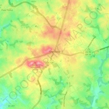
Nome: Mapa topográfico Snellville, altitude, relevo.
Local: Snellville, Gwinnett County, Georgia, United States (33.81839 -84.04291 33.89217 -83.95093)
Altitude média: 300 m
Altitude mínima: 247 m
Altitude máxima: 363 m
Faça uma doação
Outros mapas topográficos
Clique em um mapa para visualizar sua topografia, sua altitude e seu relevo.
Yellow River Post Office Site
United States > Georgia > Gwinnett County > Lilburn
Altitude média: 275 m
Faça uma doação
Pine Ridge Country Club Estates
United States > Georgia > Gwinnett County > Lawrenceville
Altitude média: 323 m
Faça uma doação