
Mapa topográfico Hof am Regen
Mapa interativo
Clique no mapa para exibir a altitude.
Sobre este mapa
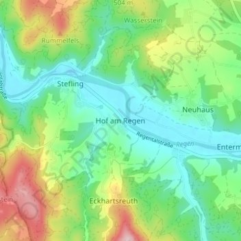
Nome: Mapa topográfico Hof am Regen, altitude, relevo.
Altitude média: 418 m
Altitude mínima: 337 m
Altitude máxima: 590 m
Outros mapas topográficos
Clique em um mapa para visualizar sua topografia, sua altitude e seu relevo.
Gunt
Deutschland > Bayern > Landkreis Schwandorf > Nittenau > Hof am Regen
Gunt, Hof am Regen, Nittenau, Landkreis Schwandorf, Bayern, 93149, Deutschland
Altitude média: 424 m