
Faça uma doação
Mapa topográfico Bower
Clique no mapa para exibir a altitude.
Faça uma doação
Bower
In The Standing Stones of Caithness (2003), Leslie J Myatt gives the alignment of the stones as 322 degrees, from the fallen stone to the still standing stone. This alignment may appear to suggest a summer solstice sunset which is too far north for the latitude. However, at about 75 metres (246 ft), the altitude of the stones is quite high with respect to an Atlantic horizon which is visible on this bearing. The sunset alignment differs from that of Maeshowe, a chambered cairn in Orkney, which is built so that sunlight will penetrate the cairn at the time of the winter solstice sunset.
Faça uma doação
Sobre este mapa
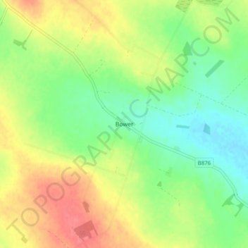
Nome: Mapa topográfico Bower, altitude, relevo.
Local: Bower, Caithness, Scotland, KW1 4TN, United Kingdom (58.52688 -3.33252 58.56688 -3.29252)
Altitude média: 47 m
Altitude mínima: 20 m
Altitude máxima: 80 m
Faça uma doação
Outros mapas topográficos
Clique em um mapa para visualizar sua topografia, sua altitude e seu relevo.