
Faça uma doação
Mapa topográfico Таскино
Clique no mapa para exibir a altitude.
Faça uma doação
Sobre este mapa
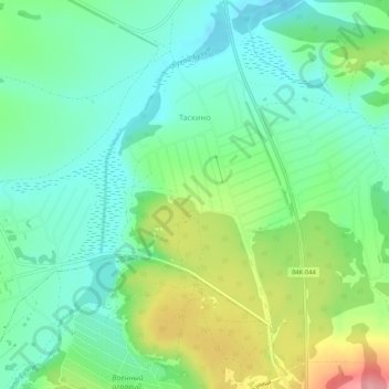
Nome: Mapa topográfico Таскино, altitude, relevo.
Altitude média: 251 m
Altitude mínima: 214 m
Altitude máxima: 328 m
Faça uma doação
Outros mapas topográficos
Clique em um mapa para visualizar sua topografia, sua altitude e seu relevo.
Siberia
Russia > Krasnoyarsk Krai > Boguchansky Rayon
Eastern and central Sakha comprises numerous north–south mountain ranges of various ages. These mountains extend up to almost 3,000 metres (9,800 ft), but above a few hundred metres they are almost completely devoid of vegetation. The Verkhoyansk Range was extensively glaciated in the Pleistocene, but the…
Altitude média: 346 m
Faça uma doação
Tunguska event
Russia > Krasnoyarsk Krai > Evenkiysky Rayon
The Tunguska event was a large explosion of between 3 and 50 megatons that occurred near the Podkamennaya Tunguska River in Yeniseysk Governorate (now Krasnoyarsk Krai), Russia, on the morning of 30 June 1908. The explosion over the sparsely populated East Siberian taiga felled a large number of trees, over an…
Altitude média: 333 m
Faça uma doação
Byrranga Mountains
Russia > Krasnoyarsk Krai > Taymyrsky Dolgano-Nenetsky District
Altitude média: 904 m
Faça uma doação
Zheleznogorsk
Russia > Krasnoyarsk Krai > Closed administrative-territorial formation of Zheleznogorsk
Zheleznogorsk is located 35 km north of Krasnoyarsk, in the foothills of the Atamanovsky Ridge, the spurs of the Sayan Mountains. The climate of the city, as in Krasnoyarsk, is Dfb according to Köppen. The average annual temperature is 2.2 °C or 36 °F. The city is located far from the southern border of…
Altitude média: 220 m
Faça uma doação
Faça uma doação
Taymyr Peninsula
Russia > Krasnoyarsk Krai > Taymyrsky Dolgano-Nenetsky District
Altitude média: 237 m
Faça uma doação
Faça uma doação
Faça uma doação
Faça uma doação
Krasnoyarsk
Russia > Krasnoyarsk Krai > Krasnoyarsk Urban Okrug
The river Yenisei flows from west to east through the city. Due to the Krasnoyarsk hydroelectric dam 32 km (20 mi) upstream, the Yenisei never freezes in winter and never exceeds +14 °C (57 °F) in summer through the city. Near the city center, its elevation is 136 m (446 ft) above sea level. There are…
Altitude média: 285 m
Faça uma doação
Matusevich Ice Shelf
Russia > Krasnoyarsk Krai > Taymyrsky Dolgano-Nenetsky District
Altitude média: 211 m
Krasnoyarsk
Russia > Krasnoyarsk Krai > Krasnoyarsk Urban Okrug
The river Yenisei flows from west to east through the city. Due to the Krasnoyarsk hydroelectric dam 32 km (20 mi) upstream, the Yenisei never freezes in winter and never exceeds +14 °C (57 °F) in summer through the city. Near the city center, its elevation is 136 m (446 ft) above sea level. There are…
Altitude média: 285 m
Faça uma doação
Faça uma doação
Faça uma doação
сельское поселение Хатанга
Russia > Krasnoyarsk Krai > Taymyrsky Dolgano-Nenetsky District
Altitude média: 157 m
Taymyr Peninsula
Russia > Krasnoyarsk Krai > Taymyrsky Dolgano-Nenetsky District
Altitude média: 237 m
Faça uma doação
городское поселение Дудинка
Russia > Krasnoyarsk Krai > Taymyrsky Dolgano-Nenetsky District
Altitude média: 271 m