
Obrigado por apoiar este site ❤️
Faça uma doação
Faça uma doação
Mapa topográfico Rancho Santa Fe
Clique no mapa para exibir a altitude.
Obrigado por apoiar este site ❤️
Faça uma doação
Faça uma doação
Rancho Santa Fe
The climate of Rancho Santa Fe is, for the most part, typical of the San Diego metropolitan area though its higher elevation and inland location lends itself to larger temperature variations.
Obrigado por apoiar este site ❤️
Faça uma doação
Faça uma doação
Sobre este mapa
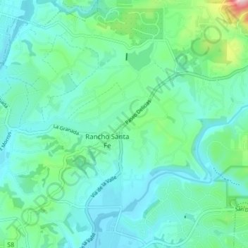
Nome: Mapa topográfico Rancho Santa Fe, altitude, relevo.
Altitude média: 68 m
Altitude mínima: 6 m
Altitude máxima: 331 m
Obrigado por apoiar este site ❤️
Faça uma doação
Faça uma doação