
Faça uma doação
Mapa topográfico Saint-Gaudens
Clique no mapa para exibir a altitude.
Faça uma doação
Saint-Gaudens
Saint-Gaudens lies at an altitude of 405 m (1,329 ft) on a ledge overlooking the valley of the Garonne. It faces the Pyrenees and is a natural crossroads for routes between the Atlantic and the Mediterranean and between Toulouse and the Val d'Aran in Catalonia. Saint-Gaudens station has rail connections to Toulouse, Bayonne, Pau and Tarbes.
Faça uma doação
Sobre este mapa
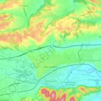
Nome: Mapa topográfico Saint-Gaudens, altitude, relevo.
Altitude média: 404 m
Altitude mínima: 335 m
Altitude máxima: 547 m
Faça uma doação
Outros mapas topográficos
Clique em um mapa para visualizar sua topografia, sua altitude e seu relevo.
Faça uma doação
Toulouse
France > Occitania > Haute-Garonne > Toulouse
The first half of the 14th century was a prosperous period, despite the dismemberment in 1317 of the very large bishopric of Toulouse (which lost two thirds of its area and a large part of its income, a loss only partially compensated by its elevation to the rank of archbishopric), and the episode of the…
Altitude média: 173 m