
Mapa topográfico Degerloch
Clique no mapa para exibir a altitude.
Sobre este mapa
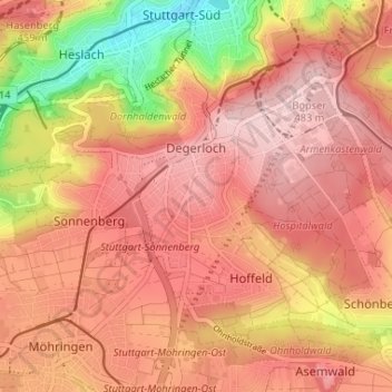
Nome: Mapa topográfico Degerloch, altitude, relevo.
Local: Degerloch, Stuttgart, Baden-Württemberg, 70597, Germany (48.72921 9.13619 48.75942 9.20131)
Altitude média: 414 m
Altitude mínima: 266 m
Altitude máxima: 488 m
Outros mapas topográficos
Clique em um mapa para visualizar sua topografia, sua altitude e seu relevo.
Stuttgart
Germany > Baden-Württemberg > Stuttgart
Stuttgart covers an area of 207.35 km2 (80 sq mi) and sits at elevation ranging from 207 m (679 ft) above sea level by the Neckar river to 549 m (1,801 ft) on Bernhartshöhe hill – something rather unique in large German cities. The most prominent elevated locales in Stuttgart are the Birkenkopf (511 m…
Altitude média: 353 m