
Faça uma doação
Mapa topográfico Curry Village
Clique no mapa para exibir a altitude.
Faça uma doação
Curry Village
The resort is 1 mile (1.6 km) southeast of Yosemite Village, at an elevation of 4,003 feet (1,220 m), and occupies a central position in the Yosemite Valley. It lies on a talus cone of debris from old rockfalls.
Faça uma doação
Sobre este mapa
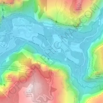
Nome: Mapa topográfico Curry Village, altitude, relevo.
Altitude média: 1.621 m
Altitude mínima: 1.203 m
Altitude máxima: 2.479 m
Faça uma doação
Outros mapas topográficos
Clique em um mapa para visualizar sua topografia, sua altitude e seu relevo.
Yosemite Valley
United States > California > Mariposa County > Yosemite Village
Altitude média: 2.016 m
Echo Valley
United States > California > Mariposa County
Echo Valley is a valley in Yosemite National Park, at an elevation of 7,021 feet (2,140 m). It is located along Echo Creek, about 3 miles (5 km) west of Merced Lake, at 37°44′38″N 119°26′03″W / 37.7438°N 119.4343°W / 37.7438; -119.4343. It is bounded on the south by the Merced River.
Altitude média: 2.333 m
Faça uma doação
Yosemite Valley
United States > California > Mariposa County > Yosemite Village
Altitude média: 2.012 m
Yosemite Valley
United States > California > Mariposa County > Yosemite Village
Altitude média: 2.016 m