
Mapa topográfico Telluride
Mapa interativo
Clique no mapa para exibir a altitude.
Sobre este mapa
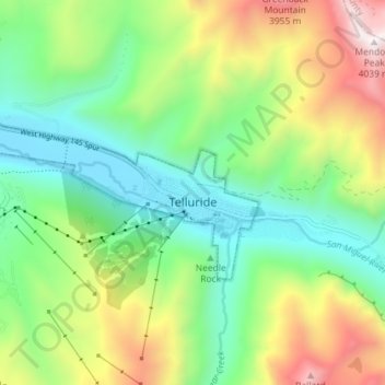
Nome: Mapa topográfico Telluride, altitude, relevo.
Altitude média: 3.125 m
Altitude mínima: 2.647 m
Altitude máxima: 4.023 m
Telluride has an elevation of 8,750 feet (2,670 m) in an isolated spot in Southwest Colorado. From the west, Colorado Route 145 is the most common way into Telluride; two other passes enter the town, Imogene Pass and Black Bear Pass.